


ISRO-NASA Launch NISAR Satellite: A New Era in Earth Monitoring
Today, ISRO and NASA are launching the NISAR satellite. This $1.5 billion mission aims to revolutionize Earth monitoring by tracking climate change, natural disasters, and land deformations with unmatched accuracy.
A Milestone for Global Earth Observation
Today marks a monumental moment in the field of space exploration and Earth science. At 5:40 PM IST, the Indian Space Research Organisation (ISRO), in collaboration with NASA, will launch the NISAR (NASA-ISRO Synthetic Aperture Radar) satellite from the Satish Dhawan Space Centre in Sriharikota. The $1.5 billion mission has the potential to change how we monitor our planet and respond to climate-related challenges. This groundbreaking satellite aims to provide precise data on global climate change, land deformations, and natural disasters, offering critical insights that could benefit millions worldwide.
For those who are fascinated by space technology and its real-world applications, the NISAR satellite promises to open up a new chapter in Earth monitoring—one that is more accurate, timely, and essential than ever before.
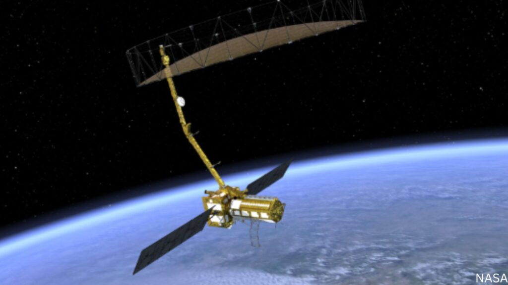
What is NISAR?
A Collaborative Endeavor Between ISRO and NASA
NISAR is a synthetic aperture radar (SAR) satellite that is the result of a collaboration between ISRO and NASA. Its primary goal is to collect detailed data about the Earth’s surface, utilizing advanced radar imaging techniques to observe changes in the environment. The satellite will continuously monitor various elements, including vegetation, ice sheets, urbanization, and the effects of natural disasters, in real time.
What sets NISAR apart from previous Earth observation missions is its cutting-edge radar system. Unlike traditional optical satellites that depend on visible light to capture images, NISAR will use radar waves to create high-resolution images of the Earth’s surface—day or night, and in all weather conditions. This means that no matter the weather, NISAR will continue to provide data, ensuring that crucial monitoring efforts are never disrupted.
The Importance of NISAR’s Mission
Tracking Climate Change and Environmental Shifts
One of the most pressing challenges of our time is climate change, and NISAR’s capabilities will make a significant impact in tracking environmental changes. By monitoring the Earth’s surface for signs of rising sea levels, deforestation, melting glaciers, and shifting weather patterns, the satellite will provide essential data to help governments, researchers, and organizations better understand the scale of climate change and the effectiveness of mitigation efforts.
Through NISAR, scientists will be able to track land deformation caused by natural and human-induced factors. This includes monitoring seismic activities, such as earthquakes, volcanic eruptions, and the movement of tectonic plates, which often go undetected by ground-based methods.
Real-Time Monitoring of Natural Disasters
A Crucial Tool for Disaster Management
NISAR’s technology also promises to become a game-changer in disaster management. The satellite will provide real-time data on natural disasters like earthquakes, floods, and landslides, allowing emergency responders to act faster and more effectively. The ability to monitor changes in the Earth’s surface, including the detection of surface displacement after an earthquake, will allow for better preparedness and response in affected regions.
The NISAR mission’s detailed radar imaging will provide insights into the conditions of disaster-stricken areas, enabling faster and more efficient humanitarian aid distribution. This capability will be especially critical in remote or affected regions where immediate access is difficult.
A Global Impact: NISAR’s Contribution to International Science
Data for All: A Shared Resource for the World
While the NISAR mission is led by India and the United States, the satellite’s data will be shared globally. The mission is designed as a collaborative effort, with data being made available to scientists and researchers from around the world. This open-access data-sharing model is crucial, as it allows for a broader understanding of the Earth’s changing environment and encourages international collaboration on issues like climate change, disaster management, and urban planning.
By providing precise, real-time data, NISAR will serve as an essential tool for scientists working on various global challenges, from monitoring agricultural health to studying the impacts of climate change on urban landscapes. Countries around the world will have access to the satellite’s findings, promoting collaboration on environmental conservation and sustainable development efforts.
The Technological Marvel Behind NISAR
What Makes NISAR Unique?
NISAR features two distinct radar systems that enable it to capture data across multiple frequencies, providing an unprecedented level of detail. The radar systems are capable of measuring tiny changes in the Earth’s surface, which would normally go undetected by other methods. These capabilities make NISAR one of the most advanced Earth-observing satellites ever built.
The satellite will utilize both L-band and S-band radar wavelengths, allowing it to study different types of Earth surface features with exceptional precision. The L-band is particularly useful for observing the movement of tectonic plates, while the S-band radar will focus on vegetation and other environmental changes. This combination of radar systems makes NISAR a versatile tool for Earth observation.
The Future of Space Collaboration
India’s Growing Role in Space Exploration
NISAR represents the growing influence of India in the global space community. The collaboration between ISRO and NASA underscores the increasing importance of international partnerships in tackling global challenges. As one of the world’s leading space agencies, ISRO has demonstrated its ability to execute ambitious missions, such as the successful Mars Orbiter Mission and the Chandrayaan missions to the Moon.
The NISAR project further solidifies ISRO’s reputation for technological innovation and international cooperation. The mission is expected to pave the way for more joint initiatives with other countries and organizations, positioning India as a key player in global space exploration and environmental monitoring.
Conclusion: A New Era in Earth Monitoring
The launch of the NISAR satellite today marks the beginning of an exciting chapter in Earth observation. With its advanced radar capabilities, the satellite will revolutionize how we monitor climate change, track natural disasters, and understand land deformations. As ISRO and NASA work together on this mission, NISAR will provide critical data that will help safeguard our planet’s future and improve global disaster management efforts.
In the coming years, as NISAR’s data continues to be analyzed and applied, we can expect to see major advancements in our understanding of the Earth’s changing environment. This mission is not just a technological achievement—it’s a global effort to address the most pressing challenges of our time.
India’s Historic Space Leap: Shubhanshu Shukla Joins Axiom Mission 4, Paving the Way for Future Space Exploration”

9rlpbu
I absolutely love your blog and find almost all of your post’s to be just what I’m looking for. Would you offer guest writers to write content for you? I wouldn’t mind creating a post or elaborating on most of the subjects you write in relation to here. Again, awesome weblog!